Last updated:
Kamloops Centre for the Arts
The Kamloops Centre for the Arts is part of the Build Kamloops vision.
Capital Projects are part of the City's Civic Operations and help maintain or improve municipal infrastructure.
The following is a list of active and upcoming capital projects in Kamloops, which may be viewed to learn about the scope, timelines and estimated costs related to each, as well as resident and/or expected traffic impacts (if applicable). You may also ask questions or leave comments for the project team's consideration.
For current traffic impact information, you can also view the Kammute page on our site.
Expand the following projects below.
The Kamloops Centre for the Arts is part of the Build Kamloops vision.
The 4th Avenue Sewer Upgrades Project is comprised of a sanitary sewer main upgrade from Lansdowne Street to Battle Street.
The recommencement of work on the Tranquille Phase 3 project will begin in early February 2026.
Construction of the roadway extension of Qu’Appelle Boulevard to Rose Hill Road will take place from late 2025 to 2027.
UPDATE FOR MAY 4
Crews are now off of the roadway and working in the greenfield section of the project. Restoration has occurred to the concrete driveway letdown and sidewalk portions that were removed to facilitate installation of the new sanitary main.
Beginning this week, crews will be gearing up for the final asphalt restoration based on the following schedule:
Thank you for your continued patience as we work to complete this project!
UPDATE FOR APRIL 9
Due to extenuating environmental circumstances outside of the City’s control, the Batchelor North Sanitary Lift Station decommissioning sequencing and timeline of work has been adjusted.
During the weeks of April 13 and April 20 (subject to change), crews will remain in the Grasslands Boulevard area and will be working on letdown and private driveway reinstatement, as well as paving. Minor traffic and
pedestrian impacts will be experienced. Please obey all signage and traffic control personnel.
Following this work on Grasslands Boulevard, crews will begin working off the road from late April to mid-May (subject to change). No traffic or resident impacts will occur during this phase.
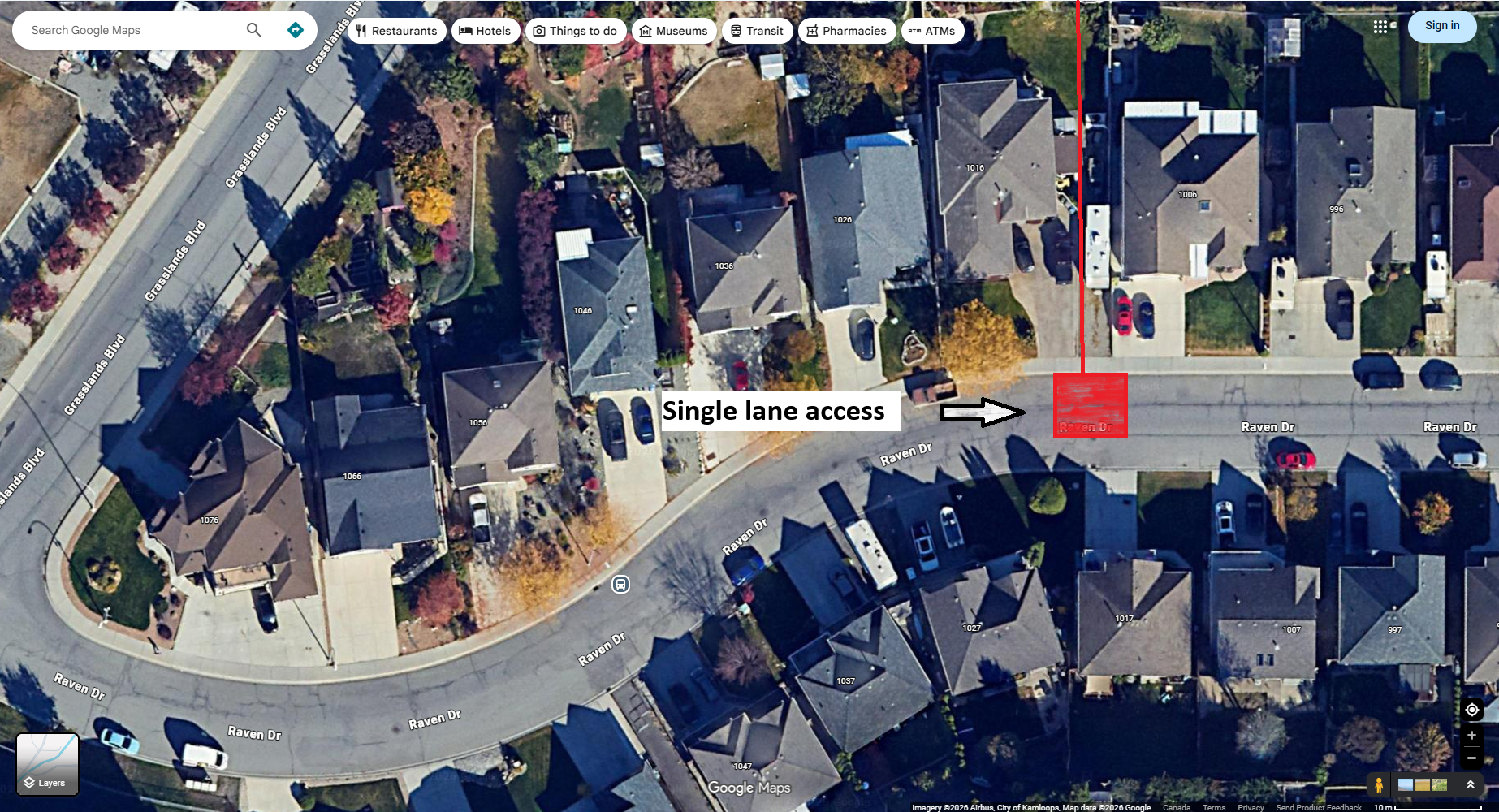
RAVEN DRIVE
Due to the above noted project delays, the overland pumping work on Raven Drive will now occur in late May/June (subject to change). As a reminder, a noise controlled generator will be setup within the roadway for overland pumping purposes, resulting in single lane traffic on Raven Drive.
HOURS OF WORK
Work will occur from 7:00 am to 5:00 pm, Monday through Thursday, with the possibility of evening and Friday/weekend work as required to help expedite the project.
Please note that timing may shift without notice. Crews will do their best to limit impacts to residents, pedestrians, and motorists.
The City thanks you for your patience and understanding!
PROJECT SCOPE
The City of Kamloops’ Civic Construction crew is advising residents of upcoming decommissioning work related to the Batchelor North Sanitary Lift Station beginning the week of March 23, 2026. The scope of work will include:
HOURS OF WORK
The City’s Civic Construction crew will work 7:00 am to 5:00 pm, Monday through Thursday.
TRAFFIC IMPACTS
Work will begin on Grasslands Boulevard the week of March 23. Crews will construct a temporary access road and perform work in the manhole adjacent to 2048 Grasslands Boulevard, resulting in a temporary road closure.

Detour route signage will be provided for traffic. Please obey all signage and traffic control personnel.
Following this work on Grasslands Boulevard, crews will begin working off the road for a short time from late March to late April. No traffic or resident impacts will occur during this phase.
In late April, crews will proceed to the lift station for additional project work. To access the lift station crews will be working on the boulevard in front of 1016 Raven Drive.
During this time, a noise controlled generator will be setup within the roadway for overland pumping purposes, resulting in single lane traffic on Raven Drive.
RESIDENT IMPACTS
Impacts to driveway access may occur for some residents on both Grasslands Boulevard and raven Drive. Those properties will be notified separately.
Pedestrian access will be maintained. No impacts to solid waste collection will occur.
Vibratory compaction equipment may be in use; therefore, any fragile items should be packaged or protected from damage due to vibration.
Throughout the length of the project, residents should expect heavy truck traffic and construction noise in the area.
TRANSIT IMPACTS
During the work on Grasslands Boulevard, transit will detour to Saddleback Drive when travelling southbound, and Stagecoach Drive when travelling eastbound.
UPDATE FOR APRIL 7
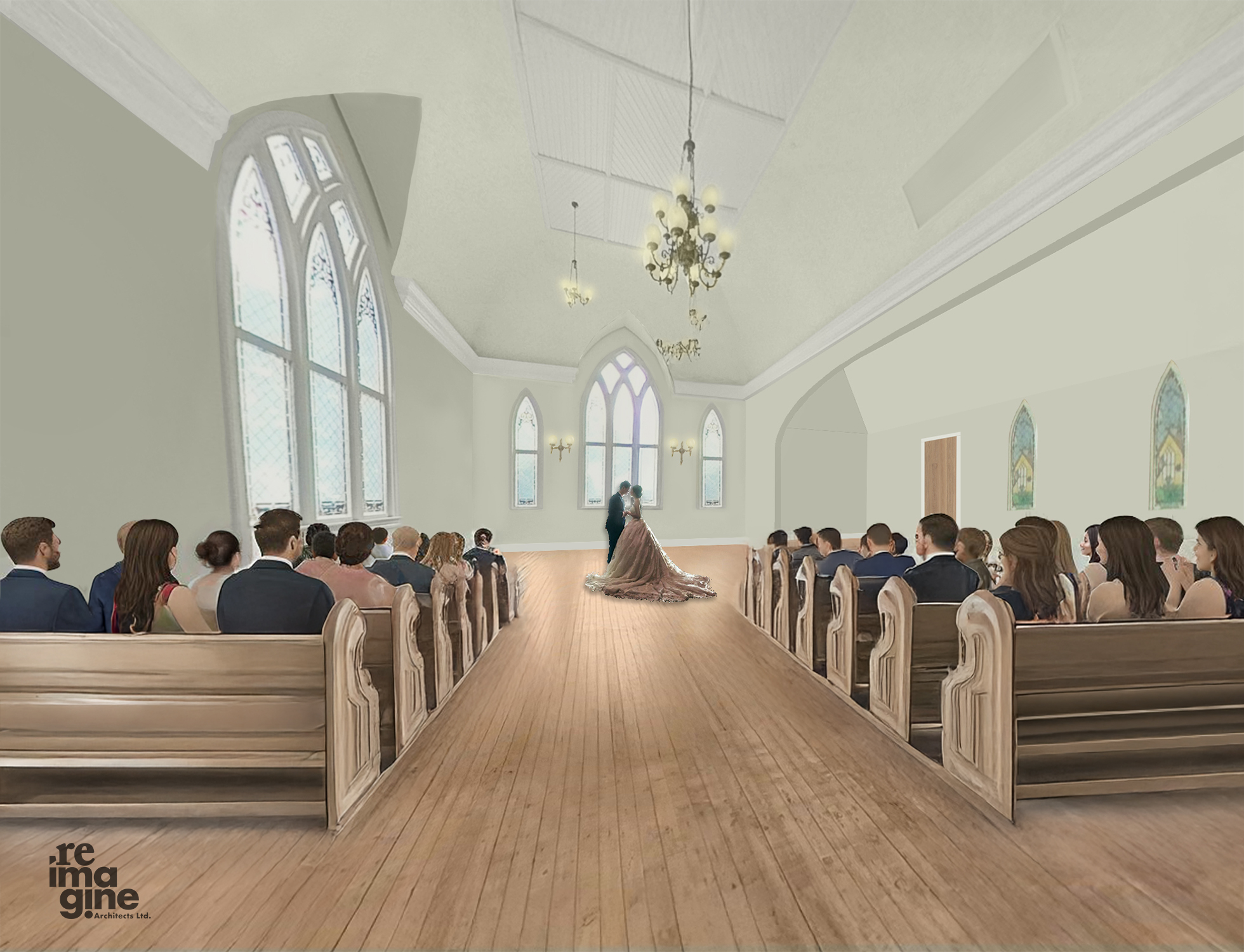
The St. Andrew’s project continues to progress well and is anticipated to reach completion in the coming weeks.
Significant interior work is nearing conclusion, including painting, audiovisual installation, life safety, millwork, flooring, lighting, and other fixtures and work is also advancing on the building’s interior features and décor. A new HVAC system is being commissioned.
Outdoors, additional improvements are in progress, including the rejuvenation of the accessibility ramp and surrounding area. The gardens and groups are being brought out of hibernation in preparation for opening.
The existing stained-glass windows are being carefully cleaned and restored, with coordination underway alongside the original artist to further highlight this prominent feature of the space.
UPDATE FOR FEBRUARY 25
The City of Kamloops is advising impacted properties of an upcoming alley closure south of Seymour Street between 1st Avenue and 2nd Avenue for Fortis work related to the St. Andrew’s on the Square Renovation Project.
The closure will occur Friday, February 27, 2026, beginning at 9:00 am, for a duration of approximately 4 hours.
Prior to 9:00 am, access and egress from the alley will be permitted with minimal delay. During the closure period, the alley will be closed at the east end at 2nd Avenue. Access will only be permitted via the laneway from 1st Avenue.
Overall completion of the project is expected in late March.
PROJECT SCOPE
The City of Kamloops has contracted DW Builders to complete restoration work at St. Andrews on the Square, returning the building to its pre-damage condition while also incorporating upgrades to improve accessibility, code compliance, and overall functionality.
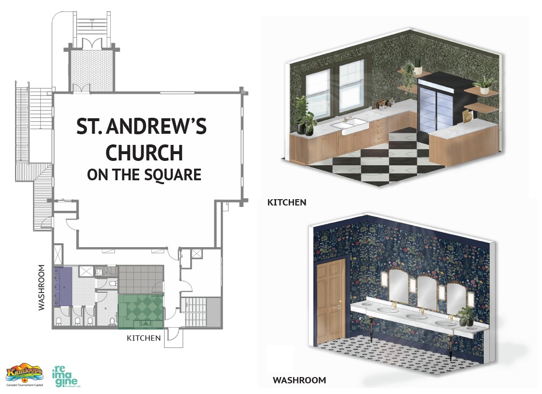
This restoration work supports maintaining a tangible link to the past, anchoring Kamloops’ identity and historical continuity, while providing a useful, functional space for events and gatherings.
In May 2024, the facility–the oldest public building remaining in the city–sustained fire damage, with most of the impact limited to the exterior and attic, while the interior was primarily affected by smoke and firefighting water.
HOURS OF WORK
The work will occur Monday through Friday, from 7:00 am to 5:00 pm, from early October 2025 to February 2026.
Some evening or weekend work may be required.
PROJECT IMPACTS
Surrounding commercial and residential properties can expect noise and truck traffic.
Traffic impacts are not expected during this project.
UPDATE FOR APRIL 24
The crew continues work in the area including testing and tie-ins. Estimated project completion date has now been moved to early June 2026.
UPDATE FOR JANUARY 26
Crews have returned to complete the remaining portions of this work, including electrical installation, and commissioning. Temporary water disruptions may occur and will be communicated to impacted properties ahead of time.
Estimated project completion date is mid-March 2026.
UPDATE FOR DECEMBER 22
The contractor will return in January (weather permitting) to continue work.
Once the building is complete, the mechanical apparatus for the pressure-reducing station will be installed. Once that is all complete, the final water connections will be done outside the building, connecting the higher-pressure zone to the lower-pressure zone (weather permitting).
UPDATE FOR JULY 10
On Friday, July 11, paving work will occur on Hillside Drive North and McGill Road just past Bunker Road.
Expect single lane alternating traffic and frequent temporary road closures to allow the movement of paving and construction equipment. Paving is expected to begin around 8:30 am on Friday.
To avoid commuting slowdowns due to moving paving equipment and single lane alternating traffic, it is recommended commuters travel along McGill Road away from the construction zone to access Summit Drive.
UPDATE FOR MAY 21
From May 23 until June 20, construction will move into the south side of Hillside Drive North. During this time, Hillside Drive North will be single lane alternating traffic moving up to Bunker Road. Traffic control personnel will be used to guide traffic.
On Saturday, June 21, there will be a temporary road closure on McGill Road just past the Bunker Road intersection. McGill Road will be accessible for local traffic only starting at the University Drive intersection. Bunker Road will be closed and traffic will exit McGill the same way it entered.
Further, the Bunker Road Recycling and Yard Waste Depot will be temporarily closed on June 21 due to the road closure.
After June 21, please expect single lane alternating traffic along within the corridor of McGill Road and Hillside Drive North as contractors pave and restore the boulevard. This work is expected to be completed by the end of July.
Note: All dates are approximate and may change based on weather and other factors.
PROJECT SCOPE
The City of Kamloops has contracted BA Dawson Blacktop Ltd. to install a watermain extension along Hillside Drive connecting the 2088 pressure zone to the 1786 pressure zone through a pressure reducing valve station.
The result will be an upgrade to water servicing in the area and improvement of fire protection to enable development of high density residential and commercial lots.

HOURS OF WORK
We are advising impacted properties that work will begin in spring 2025, with expected completion in fall 2025.
Construction is scheduled to occur Monday through Friday, 7:00 am–5:00 pm, with the possibility of some weekend work required.
IMPACTS
Throughout the project, water service disruptions may occur. Impacted properties will receive advanced notification when any planned water shutoffs are scheduled.
During construction, dust control measures will be in place, as heavy vibratory equipment will be used. Pack up fragile items to protect them from damage due to vibration. Expect heavy truck traffic and noise disruptions from construction equipment.
UPDATE FOR DECEMBER 22
The contractor will return in January and will start tunnelling under Highway 1 for the connection from Hillside Drive to Sugarloaf Road. Simultaneously, crews will continue to work on installing the sewer pipe in the lower section of the project. This will include blasting and earthworks in addition to the pipe installation.
PROJECT SCOPE
The City of Kamloops has contracted Extreme Excavating to add approximately 6.4kms of 600mm diameter and 450mm diameter gravity sanitary mains from Sugarloaf Road to Mission Flats Road.
Construction is scheduled to occur Monday through Friday, 7:00 am–5:00 pm, with the possibility of some evening and weekend work required, until summer 2026.
PROPERTY IMPACTS
Throughout the project, water service disruptions may occur. Impacted properties will receive advanced notification when any planned water shutoffs are scheduled.
During construction, dust control measures will be in place, as heavy vibratory equipment will be used. Pack up fragile items to protect them from damage due to vibration. Expect heavy truck traffic and noise disruptions from construction equipment.
PROJECT UPDATE
All roadway works have been completed, with the only remaining aspect of the project being the achievement of whistle cessation. The project team is working with all partners to achieve this final milestone and will provide an update in 2026. Thank you for your patience and co-operation thus far!
UPDATE FOR AUGUST 28
Work is scheduled to recommence on Lorne Street next week. To accommodate this work, a closure and detour will be in place on 7th Avenue from Tuesday, September 2, through Saturday, September 6 while crews build, install, and weld rail panels.
Residents on 7th Avenue will continue to have access during construction, and accommodations will be made as needed.
In addition, on Saturday, September 2, traffic will be single lane alternating on Lorne Street to support the unloading of materials.
UPDATE FOR JULY 14
Acres Enterprises has demobilized from site for a brief pause until Monday, August 11.
When the project restarts, road closures will temporarily recommence while the remainder of the work is completed.
Asphalt prep, paving, and restoration, including signage installation, will begin August 14, with overall project completion expected in September.
UPDATE FOR JUNE 13
A closure is planned at 7th Avenue and Lorne Street for construction for the Lorne Street Rail Improvement project. The closure should last 3 days while the construction crew reshapes the existing subgrade around the rail track. As of now, this is scheduled for June 16-18, but is subject to change. Please continue to monitor this page for project updates.
PROJECT SCOPE
The City of Kamloops has contracted Acres Enterprises Ltd. to perform rail safety improvements at CN Rail crossings on Lorne Street to accommodate improved safety for pedestrians, cyclists, and motorists to support the future cessation of train whistles.
The project is partially grant funded by Transportation Canada’s Rail Safety Improvement Program and will include the following elements:

HOURS OF WORK
We are advising residents that work is scheduled to begin in spring 2025, with completion anticipated in fall 2025.
Construction is scheduled to occur Monday through Friday, 7:00 am–5:00 pm, with the possibility of some weekend work required.
TRAFFIC IMPACTS
Traffic will be temporarily impacted within the construction zone, including road closures, detour routes, and single lane alternating traffic patterns.
Please plan accordingly and obey all signage and traffic control personnel.
RESIDENT IMPACTS
During construction, dust control measures will be in place, as heavy vibratory equipment will be used. Pack up fragile items to protect them from damage due to vibration.
Expect heavy truck traffic and noise disruptions from construction equipment.
PEDESTRIAN IMPACTS
During construction, sidewalk closures may be in effect. Please obey all signage when navigating the area.
UPDATE FOR DECEMBER 22
The majority of the project is complete. The contractor will return in the spring when conditions are suitable for planting and landscaping.
UPDATE FOR OCTOBER 7
Road closure:
Traffic pattern change:
Detours:
Pedestrians:
No parking:
Bus stop:
After hours:
PROJECT SCOPE
The City of Kamloops has contracted Extreme Excavating Ltd. to perform sewer upgrades to the existing sanitary line between Monarch Drive and Waddington Drive, adjacent to Springhill Creek. The current sanitary line is aging and does not have enough capacity to meet the current demand.
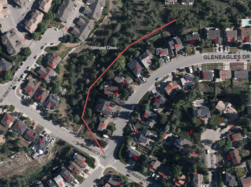
The project will also include the creation of an access road at the corner of Gleneagles Drive and Monarch Drive, removal and replanting of trees and vegetation, reseeding disturbed areas outside of the road alignment, and upgrades to the walking path.
We are advising residents that this work is scheduled to begin in early October, with expected completion in December 2025.
Construction is scheduled to occur Monday through Friday, 7:00 am–5:00 pm, with the possibility of some evening and weekend work required.
TRAFFIC IMPACTS
While some work will occur in the intersection of Monarch Drive and Gleneagles Drive, overall traffic impacts during this work will be minimal.
Please obey all traffic control personnel and signage when crews are in the area.
RESIDENT IMPACTS
Work will begin at Monarch Drive and end near Waddington Drive. The bulk of of the work will occur in the greenspace near Springhill Creek.
During the work, water service disruptions may occur. Impacted residents will receive advanced notification when any planned water shutoffs are scheduled.
Throughout the construction period, vibratory compaction equipment may be in use; therefore, any fragile items should be packaged or protected from damage due to vibration.
As this project location is in close proximity to streams, riparian areas, and wildlife, the City is abiding by an Environmental Management Plan that will help mitigate and minimize the potential for adverse environmental impacts, as well as provide best practices for how best to manage the work in this area.
PEDESTRIAN IMPACTS
For safety reasons, the green space and walking trail within construction zone will be closed for the duration of the construction project. Please obey all posted signage.
PROJECT SCOPE
The City of Kamloops has contracted Interior Dams to facilitate the decommissioning and removal of the Rea Lake Dam structure, as part of the Jamieson Creek Dams regulatory compliance program, initiated by the Province’s Dam Safety Officer.
This project is required to eliminate a dangerous condition at the Rea Lake Dam.
PROJECT TIMELINE
Work will occur from mid-January to mid-March 2026
NOTE: work must be completed prior to Freshet 2026.
PROJECT IMPACTS
Impacts to residents will be minimal.
Please note that we are only able to respond during regular City operating hours, 8:00 am–4:00 pm, Monday to Friday (excluding holidays). Any emergency issues or requests for service should be directed to 250-828-3461.
To ask a question you must create an account or log in.
These are the people that are listening and responding to your questions.

{{question.description}}
![]()
Have questions or want to learn more about a project, contact us below:
| Website | www.kamloops.ca |
|---|---|
| In writing | City of Kamloops, 7 Victoria Street West, Kamloops BC, V2C 1A2 |
The City of Kamloops acknowledges that we are located on Tk̓emlúps te Secwépemc territory, situated within the unceded ancestral lands of the Secwépemc Nation.
We honour and respect the people, the territory, and the land that houses our community.